Scenario Planning Model
![]()
The SCAG Scenario Planning Model (SPM) is a comprehensive online land use sketch planning tool for data organization, scenario development, and modeling, developed to facilitate an informed and collaborative planning among counties, subregions, local jurisdictions, stakeholders, and the public.
Built on open-source software platforms, SPM includes a suite of tools and analytical engines that quickly illustrate alternative plans and policies and estimate transportation, environmental, fiscal, public health, and community impacts. SPM also provides a common data framework within which local planning efforts can be easily integrated and synced with regional plans.
SPM Features and Workflow
Timeline
2008 Senate Bill (SB) 375 | Sustainable Communities and Climate Protection Act (SB375) signed into law, setting regional targets for reducing greenhouse gas emissions from passenger vehicles. |
2010 Local Sustainability Planning Tool (LSPT) |
|
2013-2016 Scenario Planning Model (SPM) | Collaborated in customizing UrbanFootprint modeling platform which was utilized in the development and analysis of 2016 Regional Transportation Plan and Sustainable Communities Strategy (RTP/SCS) and branded as Scenario Planning Model (SPM). |
2017 SPM Data Management Tool | SPM Data Management tool, developed from a bottom-up process involving local representatives was released to all local jurisdictions to support the Connect SoCal 2020 local review and input process. |
2018-current SPM Scenario Analysis | SPM analysis modules updated and fully operationalized, producing performance and co-benefit measures for the regional plans. |
2023 Walk and Bike Accessibility Module | Integrated walk and bike accessibility module into the suite of SPM analysis modules. |
Features
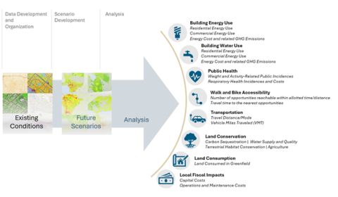
SPM provides a powerful and dynamic scenario creation, modeling, and data organization planning tool to facilitate informed and collaborative planning by providing a comprehensive view of potential futures. SPM’s suite of tools and analytic engines enable the creation and organization of local and regional data, plans, and policies; facilitate scenario creation and editing; and estimate a wide range of potential benefits resulting from alternative transportation and land use strategies.
- Data Development and Organization
Scenario-based planning with SPM starts with a detailed baseline assessment of the existing conditions. SPM streamlines the development of this highly detailed “canvas” of data by normalizing data of varying quality, type and scale from a wide range of sources, including land cover, environmental data, demographic characteristics, roadways, and transit, which provide context for scenario painting and editing as well as subsequent analysis.
- Scenario Development
SPM scenarios are created by analyzing or translating key characteristics of future year conditions, such as density, mix of uses, and street connectivity into SPM’s common language of Place Types and Building Types. Place Types represent a full range of potential development types and patterns from across the SCAG region. Each Place Type includes a mix of different building types and represents a unique set of assumptions that facilitate scenario modeling and testing at a variety of scales. This allows SCAG to integrate local plans together into a common regional fabric of land use and transportation plan and to perform consistent analysis on individual plans or combinations thereof.
- Scenario Analysis
SPM produces a wide range of inter-related metrics that allow for robust and meaningful comparisons of alternative land use and transportation scenarios. These scenarios run through SPM’s analysis modules briefly described below to measure their performance for mobility, air quality, public health, fiscal impacts, resource consumptions, and others.
Building Energy Module
The Energy module computes residential and commercial building energy use, and their related costs and greenhouse gas emissions. Within the module, building characteristics and climate zone determine baseline energy use factors. Reductions are then applied to the resulting baseline estimates to reflect the implementation of building efficiency and conservation policies into the future.
Building Water Module
The Water module calculates indoor and outdoor residential and commercial water use and their related costs and greenhouse gas emissions. Indoor and outdoor water use is calculated according to baseline rates, determined by building or employment characteristics and climate zone and then adjusted to account for the application of efficiency and conservation policies into the future.
Public Health Module
The Public Health module measures the impact of land use patterns and urban form on a range of health-related metrics within two broad categories: those that are derived from factors influenced by changes in urban form, including physical activity-related weight and disease incidences; and those that are derived from changes in travel behavior as expressed by VMT, including pollution-related respiratory impacts.
Accessibility Module
The Accessibility module evaluates the level of opportunities accessible by active modes of travel, including walking, biking, and transit. Based on an integrated active transportation network, accessibility can be measured for each mode as the number of opportunities reachable within a specified amount of time or travel times to the nearest amenities.
Transportation Module
The Transportation module estimates trip generation by different trip purposes and models in response to changes in land use pattern or policy options. By referencing forecasts obtained from SCAG’s Activity Based Model (ABM) that simulates daily activities and travel patterns of all individuals in the region, the SPM transportation module represents the ABM’s detailed insight into complex relationship while allowing quick calculation of trips and vehicle miles traveled.
Land Conservation Module
The Land Conservation module measures the impacts of land use and land cover scenarios on conservation opportunities and ecosystems. Built upon a detailed depiction of existing conditions, the impact of land use changes are measured on the themes of carbon, water, agriculture, and habitat.
Land Consumption Module
The Land Consumption module assesses how land use is developed in a future scenario. In the context of the model, “land consumption” refers to the measurement of land area needed to accommodate new growth on ”greenfield” or previously undeveloped land.
Fiscal Impact Module
The Fiscal Impact module evaluates the implications of new residential development on local expenditures by accounting for the capital costs of new and upgraded infrastructure and local operations and maintenance costs to serve new and upgraded infrastructure.
SPM Resources
These helpful links are designed to provide additional information related to land use and transportation scenario planning tools and strategies.
For additional information about the SPM, contact:
SCAG SPM team: spm@scag.ca.gov
- AllTransit
A data and analysis platform developed by the Center for Neighborhood Technology (CNT) that provides an overall transit score that looks at connectivity, access, and frequency of service.
- APA Scenario Planning
The American Planning Association’s Research KnowledgeBase curated collections on scenario planning.
- Cal-Adapt
Cal-Adapt delivers critical climate data and cutting-edge tools to empower communities, researchers, and decision-makers to take action now and provides the insights needed to adapt, build resilience, and drive urgent solutions for a sustainable future.
- CalEnviroScreen 4.0
CalEnviroScreen is a mapping tool that helps identify California communities that are most affected by many sources of pollution, and where people are often especially vulnerable to pollution’s effects. CalEnviroScreen uses environmental, health, and socioeconomic information to produce scores for every census tract in the state.
- California Healthy Places Index (HPI)
An online data and mapping tool developed by the Public Health Alliance of Southern California that provides health-related data and maps for neighborhoods, census tracts, and other geographic areas.
- CARB Pollution Mapping Tool (v3.0 beta)
Mapping tool by the California Air Resources Board that enables users to locate, view, and analyze emissions of greenhouse gases (GHG), criteria pollutants, and toxic air contaminants from large facilities and on-road motor vehicles in California.
- Conservation Assessment and Planning Tools
A collection of tools from the Conservation Effects Assessment Project (CEAP) led by the U.S. Department of Agriculture that support conservation assessment and planning for land uses and management goals.
- Consortium for Scenario Planning
Established in 2017 by the Lincoln Institute of Land Policy, the Consortium is a community of practice for individuals and organizations to increase the practice, accessibility, and resources of scenario planning and to expand scenario planning.
- FHWA Scenario Planning and Visualization in Transportation
Provide noteworthy practices and innovative uses of Scenario Planning applications for transportation planning.
- GreenTRIP Connect
An online tool developed by Transform CA and the Center for Neighborhood Technology (CNT) that helps communities, developers, and residents calculate the transportation and environmental impacts of proposed residential developments.
- ITHIM USA
A part of the ITHIM family, which stands for Integrated Transport and Health Impact Model. ITHIM is a planning tool that calculates the change in deaths, years of life lost, disability, and costs due to these changes in air pollution, physical activity, and traffic injuries.
- Opening Access to Scenario Planning Tools
This report examines the current state of scenario planning, the promise of scenario planning tools to help us prepare for the future, the challenges to expanding their use, and their potential to open access to the planning process.
- SB743 Implementation Resources
A collection of SB743 implementation resources by the California Department of Transportation (Caltrans) that provides guidance, data, and tools to help local governments and developers.
- Sketch Tools for Regional Sustainability Scenario Planning
This report synthesizes the state of practice on scenario planning sketch tools to support regional sustainability, evaluates their relative strengths and weaknesses, provides guidance on their appropriate use, and suggests how they may be improved.
- Smart Growth Tools
A collection of tools and resources by the U.S. Environmental Protection Agency (EPA) about creative and sustainable development approaches.