- Connect SoCal
- Inclusion, Diversity, Equity & Awareness
- Programs & Projects
- Housing
- Economy & Demography
- Federal & State Compliance
- Sustainable Development and Resilient Communities
- Transportation
- Active Transportation
- Planning For Main Streets
- Aviation Program
- Regional Pilot Initiatives Program
- Future Communities Pilot Program
- Transportation Demand Management
- Transit Program
- FreightWorks
- Passenger Rail Program
- Corridor Planning
- Transportation Safety
- Transportation Finance
- Intelligent Transportation Systems
- Southern California Transportation Study
- LA28 Games Mobility Program
- Local Resources
- Funding & Programming
- Legislation & Advocacy
- Publications & Reports
Transportation
As the designated Metropolitan Planning Organization (MPO) for Imperial, Los Angeles, Orange, Riverside, San Bernardino and Ventura Counties, SCAG is mandated by the federal government to develop a multimodal long-range transportation plan that provides a 20-year vision for investing in our transportation system, and update it at least once every four years. Our plan, the Regional Transportation Plan/Sustainable Communities Strategy (RTP/SCS), addresses all modes of our transportation system, and reflects research and policy initiatives from each mode: active transportation, aviation and airport ground access, corridor planning, goods movement, high-speed rail, intelligent transportation systems, safety and security, transit, and transportation finance.
Transportation Trends Report
The SCAG region is home to a diverse and expansive mobility ecosystem, with public transit operators delivering services that span local fixed-route bus systems, regional transit networks, intercity services, and commuter rail—reflecting the region’s varied geography and population density.
SCAG releases the bi-annual “Transportation Trends Report” to provide a timely assessment of transit ridership statistics, roadway performance measures, and telework patterns.
To complete the latest version of this report, SCAG analyzed data through December 2025 for a core subset of transit agencies that represents a cross-section of public operators, including municipal systems, joint powers authorities, county transportation commissions, and transit districts.
As of December 2025, transit ridership and vehicle miles traveled in the SCAG region have continued to recover from the impacts of the COVID-19 pandemic, though patterns vary by mode. Across all transit modes, bus ridership has led the recovery, followed by light and heavy rail, while commuter rail has been the slowest to return to pre-pandemic ridership levels. For automobile traffic, overall vehicle miles traveled is at 98 percent of pre-pandemic levels. Remote work continues to be a key factor in travel trends; approximately 33 percent of workdays were performed from home over the last year, contributing to reduced peak-hour demand across all travel modes.
Read the “Transportation Trends Report” online for a complete report on the state of Southern California mobility.
- Related Links & Resources
Transportation Funding in California
This California Department of Transportation (Caltrans) PDF brochure includes charts prepared as visual aids to show the sources and distribution of transportation funds in California.The California Department of Transportation
The California Department of Transportation (Caltrans) improves mobility across the state with core programs in Aeronautics, Highway Transportation, Mass Transportation, Transportation Planning, Administration and the Equipment Service Center.US DOT Federal Highway Administration
The Federal Highway Administration (FHWA) provides stewardship over the construction, maintenance and preservation of the nation’s highways, bridges and tunnels.

Active transportation refers to human powered transportation, and low speed electronic assist devices. Examples include but are not limited to bicycles, e-bicycles, tricycles, wheelchairs, electric wheelchairs, scooters, e-scooters, skates and skateboards.
Active transportation is a critical component in meeting environmental, economic and equity goals, as well as supporting jurisdictions in addressing their diverse transportation needs.
Contact
For more information on the Active Transportation Program, please contact:
Rachel Om
Senior Regional Planner
Mobility Planning and Goods Movement
om@scag.ca.gov
(213) 630-1550
- Active Transportation Plan Funding
- California Active Transportation Data Portal
- Active Transportation Plan Toolkit
Active Transportation Plan Funding
The California Active Transportation Program (ATP) was created by Senate Bill 99 (Chapter 359, Statutes 2013) and Assembly Bill 101 (Chapter 354, Statutes 2013), to encourage increased use of active modes of transportation, such as biking and walking. The ATP consolidates existing federal and state transportation programs, including the Transportation Alternatives Program, Bicycle Transportation Account and State Safe Routes to School, into a single program focused on making California a national leader in active transportation.
The california ATP has six main goals:
- Increase the proportion of trips accomplished by biking and walking.
- Increase the safety and mobility of non-motorized users.
- Advance the active transportation efforts of regional agencies to achieve greenhouse gas reduction goals as established pursuant to Senate Bill 375 (Chapter 728, Statutes of 2008) and Senate Bill 391 (Chapter 585, Statutes of 2009).
- Enhance public health, including reducing childhood obesity through programs including, but not limited to, projects eligible for Safe Routes to School Program funding.
- Ensure that disadvantaged communities fully share in the benefits of the program.
- Provide a broad spectrum of projects to benefit many types of active transportation users.
For more information, please visit California Transportation Commission ATP and Caltrans ATP.
Statewide and Regional Funding Opportunities
Active Transportation Program (ATP) funding is awarded to projects in the SCAG region through two funding programs: the Statewide ATP and SCAG’s Regional ATP. The statewide guidelines and regional guidelines direct project selection for each of the respective programs. Applications submitted to the statewide call for projects but unsuccessful in receiving funding are automatically considered for funding in the regional ATP. There is a consolidated call for projects for both funding programs issued by the California Transportation Commission (CTC) in spring of every even year (e.g. 2026) to solicit applications for all eligible project types.
Active Transportation Program Cycle 8
Active Transportation Program (ATP) Cycle 8 will offer an estimated $619 million in funding across the state, with an estimated $128 million set aside for SCAG’s Regional Active Transportation Program. ATP Cycle 8 includes funding for fiscal years 2027-28 through 2030-31. The state’s ATP guidelines require the following for SCAG’s Regional Active Transportation Program:
- A minimum of 25 percent of regional funds must benefit disadvantaged communities. The ATP state guidelines provide multiple definitions for disadvantaged communities, including regional definitions, such as SCAG’s Priority Equity Communities.
- A maximum of two percent of regional funds for the development of plans, such as active transportation plans, safe routes plans, and bicycle or pedestrian plans; all plans must benefit disadvantaged communities.
The statewide ATP call for projects includes the following project types:
- Infrastructure Projects: Capital projects that typically include the environmental, design, right-of-way, and construction phases of a capital project (i.e., facilities) .
- Plans: The development of a community-wide bicycle, pedestrian, safe routes to school or active transportation plan that encompasses or is predominately located in a disadvantaged community.
- Non-Infrastructure Projects: education and encouragement programs.
- Infrastructure Projects with Non-Infrastructure Components: Capital projects with education or encouragement components.
The following are anticipated key dates for ATP Cycle 8:
| Action | Date |
|---|---|
| Draft ATP Regional Guidelines go before SCAG Regional Council for adoption | March 5, 2026 |
| ATP State Guidelines go before California Transportation Commission for adoption | March 19, 2026 |
| Statewide ATP call for projects scheduled to open | March 19, 2026 |
| Statewide ATP call for projects scheduled to close | June 22, 2026 |
| California Transportation Commission adopts ATP Cycle 8 Statewide and Small Urban & Rural Components | Dec. 3-4, 2026 |
| Draft SCAG Regional ATP goes before SCAG Regional Council for adoption | April 1, 2027 |
| SCAG Regional ATP goes before California Transportation Commission for adoption | June 2027 |
California Active Transportation Data Portal
The California Active Transportation Data Portal (CAT Data Portal) was developed to collect, store, and visualize bicyclist, pedestrian, wheelchair, and other micromobility device volume for infrastructure and planning projects across California.
The CAT Data Portal builds on SCAG’s Active Transportation Database (ATDB), which collected and stored bicyclist and pedestrian data for the SCAG region. SCAG’s ATDB was migrated to Caltrans and UC Berkeley SafeTREC in 2024 as part of the development of a statewide database. The CAT Data Portal was launched in 2025.
Active Transportation Plan Toolkit
SCAG’s Active Transportation Plan Toolkit is a suite of resources for communities to develop an active transportation plan. This page offers information about the toolkit, including how it was developed, what’s included, who it serves, and how to access it.
Disadvantaged Communities Active Transportation Planning Initiative
The toolkit, released in 2019, marks the culmination of the Disadvantaged Communities Active Transportation Planning Initiative, a 2.5-year effort to address fatalities and serious injuries from traffic collisions concentrated on a small number of streets in Southern California, with more severe impacts for people walking and bicycling, known as the High Injury Network.
In total, 56 percent of the SCAG region's High Injury Network is located in Disadvantaged Communities (DACs), and less than 26 percent of these communities have existing active transportation plans, which creates barriers to processes of securing funding, implementing comprehensive networks, and improving access, safety, and health.
SCAG launched the Disadvantaged Communities Active Transportation Planning Initiative in 2019 to develop, pilot, and refine the toolkit in partnership with seven DACs in the region: Adelanto, Calipatria, Highland, Perris, Santa Fe Springs, Saticoy, and Stanton. These communities offered diverse contexts for developing a customizable and useful toolkit by spanning urban and rural settings, incorporated and unincorporated status, and all six counties within the SCAG region.
The pilot process culminated in seven complete active transportation plans in which more than 3,000 community members helped develop over 317 miles of recommended improvements for walking and biking.
Active Transportation Plan Toolkit Components
The Active Transportation Plan Toolkit consists of three parts:
1. Manual: Provides an overview of the process behind and how-to guide for using the Active Transportation Plan Toolkit.
2. Template: Includes a customizable Active Transportation Plan document template consisting of all required and best-practice elements.
3. Resources: Offers a suite of materials to guide the planning process and support community engagement, data analysis, project scheduling, graphics, adoption, implementations, and more.
Centering Equity and Impacted Residents
Rooted in improving outcomes for areas of persistent poverty, the pilot process and Active Transportation Plan Toolkit are guided by an Outreach and Equity Framework that invites vulnerable residents to take an active role in the planning process. Communities that use the toolkit are encouraged to develop community advisory committees and partner with community-based organizations to utilize a variety of engagement activities and serve diverse residents.
Who Can Use the Toolkit?
Designed to provide a low-cost model for communities throughout the SCAG region to develop their own active transportation plans, the Active Transportation Plan Toolkit is available at no cost for use by cities, counties, and other governmental agencies, as well as community groups and leaders to conceptualize, articulate, and implement plans to support walking and biking. Although developed for the SCAG region, communities throughout California and beyond may access and customize the toolkit accordingly.
Communities might also find the toolkit useful for active transportation planning work beyond developing a full plan (e.g., learning about active transportation, developing new programs, and conducting outreach during project implementation).

Where Transportation Innovation and Equity Intersect
The Regional Pilot Initiatives (RPI) program carries out demonstrations of next-generation technologies and models of regional significance to test strategies that can guide the region toward a brighter future. Selected projects advance implementation of the Connect SoCal 2024 Regional Transportation Plan/Sustainable Communities Strategy and rely on public and private partnerships for success.
Shaped by SCAG’s RPI Framework, SCAG has advanced pilot development for four RPI program areas. SCAG is leveraging federal funds from the Carbon Reduction Program and state funds from the Regional Early Action Planning program of 2021 to fund these projects.
For more information on RPI projects, please email contact@scag.ca.gov.
- Big Data Research
- Metrolink Contactless Payment Pilot Project
- Accelerating Active Transportation
- Mobility Hubs
Big Data Research
Transportation Data Analysis Technical Assistance Program
The (TA Program) equips public agencies with no-cost, big data analytics to answer high-priority transportation and policy questions. This program leverages StreetLight Insight® to analyze multimodal travel patterns, congestion, safety, and infrastructure performance, translating complex datasets into actionable insights for local decision-making.
In July 2026, SCAG’s TA Program published five new white papers that showcase how big data analytics can support local mobility planning in Southern California. The case studies examine distinct mobility challenges in the cities of Anaheim, Culver City, Pasadena, and Pomona, as well as in San Bernardino County.
SCAG solicited research questions from public agencies and then selected the five case studies to demonstrate practical applications of mobility analytics to address transportation safety, congestion, transit performance, demand management, and land use impacts.
During the demonstration process, SCAG’s TA Program helped agencies refine research questions, apply innovative analytical approaches, build data literacy, and develop replicable methods for integrating new data sources into transportation decision-making. SCAG’s regional subscription to StreetLight Insight® provided participating agencies with access to multimodal travel data, origin-destination analysis, safety analytics, speed data, and other mobility insights.
SCAG TA Program White Papers
- City of Anaheim – Multi-Modal Opportunity Network
- City of Culver City – Public Accessway Network Analysis
- City of Pasadena – Corridor Characterization Analysis
- City of Pomona – Complete Streets Analysis
- San Bernardino County Transportation Authority – Understanding Commute Patterns to Support Rideshare Programs
Metrolink Contactless Payment Pilot Project
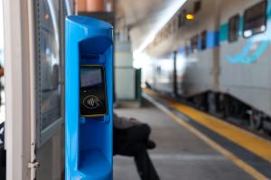
SCAG is proud to support the implementation of contactless payment for the region’s transit systems with $2.8 million in funding for the Southern California Regional Railroad Authority’s (Metrolink) Contactless Payment Pilot project, which opened for service in June 2026 on the Arrow and San Bernardino lines.
With funding administered by SCAG from the Regional Early Action Planning Grant Program of 2021 and the Carbon Reduction Program, Metrolink’s contactless payment system, also known as an “open loop” payment system, promises to improve customer experience on transit in Southern California and advance the region’s readiness for the 2028 Summer Olympic and Paralympic Games, FIFA World Cup 2026, and future mega events.
Contactless payment is a secure, cash-free method to pay transit fares by tapping or holding a payment card, smartphone, or smartwatch on a payment terminal. This technological innovation is becoming more common around the region and the nation and is considered an important upgrade in advancing a more seamless, connected, and rider-focused transportation experience. Projects like Metrolink’s Contactless Payment Pilot explore new ways to simplify transit access and improve the overall customer experience.
Accelerating Active Transportation
Watts Rising E-Bike Lending Library Program:
In partnership with the Housing Authority of the City of Los Angeles and the East Side Riders Bike Club, the Watts Rising E-Bike Lending Library Pilot Program establishes an electric bike lending library located at the Nickerson Gardens housing development in the Los Angeles neighborhood of Watts. This project would maintain a fleet of up to 100 E-bikes, stored and managed at Nickerson Gardens, for rent and would serve the development’s 3,000 residents in addition to those residing in the adjacent Watts neighborhood.
Current Status: Program is in planning and design phases with expected launch in Fall/Winter 2026.
Mobility Hubs
Mobility Hubs (In Development):
SCAG is in the process of developing pilot projects that demonstrate concepts from SCAG’s “Mobility Hub Design and Implementation Guide.” Mobility hubs centralize access to transportation amenities and services such as bikeshare, bus, train, and carshare to provide a more seamless experience for travelers during journeys. Future pilot projects could feature amenities such as device charging ports, Wi-Fi access, place-making elements, and real-time travel information to create a comfortable experience for travelers.
Current Status: Project is in its early initiation phase.

Transportation Demand Management (TDM) is a set of strategies aimed at increasing the efficiency of the transportation system, reducing vehicle miles traveled and greenhouse gas emissions through alternative modes of travel. TDM investments reduce congestion and shift trips from single occupancy vehicles to other modes through projects that often cost significantly less than roadway or transit capital expansion projects. TDM strategies and options add transportation choices that improve sustainability, public health and the quality of life by reducing congestion, air pollution, and greenhouse gases.
contact
For more information, please contact:
Turner Lott
Senior Regional Planner
contact@scag.ca.gov
Strategic Plan

In 2019, SCAG completed the Transportation Demand Management (TDM) Strategic Plan, which outlined strategies to expand the effectiveness and use of TDM to achieve regional goals. The TDM Strategic Plan included many resources for local agencies to help with TDM programming, including an overview of new mobility and technology advances as well as an updated TDM toolbox to support relieving congestion and commuting pain points. The TDM Strategic Plan also outlined recommendations that SCAG has begun implementing. To begin implementing the Plan, SCAG has initiated two of the recommended strategies —TDM Trainings and TDM Data Standards — aimed at increasing TDM adoption and strengthening TDM programs.
Training Resources
SCAG hosted a series of introductory TDM trainings in 2021 which provided information about TDM policies and programs that can be implemented in the region.
SCAG hosted a second round of advanced TDM trainings in the spring of 2022. This series built upon the TDM 101 series and provided an in-depth discussion of specific topic areas with case studies, subject matter experts, and actionable materials for attendees to use.
Download and share the TDM Trainings Final Report.
SCAG’s Aviation Program is responsible for developing the aviation element of the Connect SoCal Regional Transportation Plan/Sustainable Communities Strategy, gathering data and conducting research on aviation trends and issues, collaborating with airports and partner agencies (e.g., the Federal Aviation Administration and the Caltrans Division of Aeronautics) on airport ground access and aviation systems planning, staffing the Aviation Technical Advisory Committee, and providing information and data to the Transportation Committee.
Statistics & Analysis
Explore historical and current data from each SCAG commercial airport. Information on air passengers, tons of air cargo, and aircraft operations is collected monthly and compiled annually.
- SCAG Commercial Airport System Map
- SCAG Region (BUR, SNA, LGB, LAX, ONT, PSP)
- Hollywood Burbank Airport (BUR)
- John Wayne Airport (SNA)
- Long Beach Airport (LGB)
- Los Angeles International Airport (LAX)
- Ontario International Airport (ONT)
- Palm Springs International Airport (PSP)
- Palmdale Regional Airport (PMD)
Resources
Information about aviation systems planning and research, and some of the airports in the region, can be found on the following websites.
- State, Federal, and International Agencies
Airport Cooperative Research Program (ACRP)
Part of the National Academies, the program conducts research and guidance for near-term issues facing the aviation industry.Caltrans Division of Aeronautics
The Caltrans Division of Aeronautics conducts safety inspections of airports in California and guides land use compatibility near airports.Federal Aviation Administration (FAA)
The Federal Aviation Administration regulates the air transportation system in the United States to ensure safety and efficiency.International Air Transport Association (IATA)
The International Air Transport Association supports aviation with global standards for airline safety, security, efficiency, and sustainability.International Civil Aeronautics Organization (ICAO)
The International Civil Aeronautics Organization is an agency of the United Nations and sets safe and orderly standards for international airport development.- Commercial Service and Select General Aviation/Reliever Airports
Imperial County – Imperial County Airport (IPL)
The Imperial County Airport is the only commercial service airport in Imperial County.Los Angeles County – Hollywood Burbank Airport (BUR)
The Hollywood Burbank Airport, formerly Bob Hope Airport, is a medium hub commercial airport served daily by 29 Metrolink and 10 Amtrak trains.Los Angeles County – Long Beach Airport (LGB)
In 2012, the Long Beach Airport opened a new, modern, comfortable, and inviting passenger terminal.Los Angeles County – Los Angeles International Airport (LAX)
The Los Angeles International Airport is the most common departure airport in the world.Los Angeles County – Palmdale Airport (PMD)
The city of Palmdale owns the Palmdale Airport.Orange County – John Wayne Airport (SNA)
The John Wayne Airport is the only commercial service airport in Orange County. The airport has nonstop service to over 20 destinations.Riverside County – March Inland Port (RIV)
March Inland Port features the longest runway in California, measuring 13,300 feet.Riverside County – Palm Springs International Airport (PSP)
The Palm Springs International Airport was named one of the top 10 U.S. “Most Stress Free” airports by smartertravel.com.San Bernardino County – Ontario International Airport (ONT)
The Ontario International Airport has seven passenger airlines that offer over 420 flights per week.San Bernardino County – San Bernardino International Airport (SBD)
The San Bernardino International Airport has appeared in numerous Hollywood productions, including The Fast and the Furious, The Aviator, and Terminator 3.San Bernardino County – Southern California Logistics Airport (VCV)
The Southern California Logistics Airport, the former George Air Force Base, boasts 360 days per year of Visual Flight Rule conditions.Ventura County – Oxnard Airport (OXR)
Oxnard Airport (OXR) The Oxnard Airport has been a Ventura County asset for over 65 years.
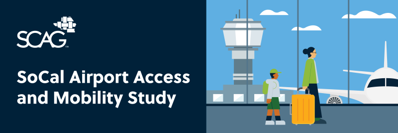
SoCal Airport Access and Mobility Study
SCAG is launching a regional airport passenger and employee survey to improve understanding of how people travel to and from Southern California’s airports. The study will analyze ground access patterns, preferences, and challenges to support planning for congestion relief, safety, and multimodal connectivity.
Project Goals
The project seeks to provide data that informs airport access improvements, encourages alternatives to private auto use, and supports regional planning efforts leading up to major events like the 2028 Summer Olympic and Paralympic Games.
Study Work
The project begins with an existing conditions analysis, documenting the region’s airports, access facilities, and connecting transportation networks. Following this, SCAG, working with a consultant team, will design and administer passenger and employee surveys—both in-person and online—to capture travel behavior, access choices, and user preferences. The collected data will then be analyzed, summarized, and published in technical reports to guide regional planning and airport access improvements.
Airports Included In The Study
The study will cover the region's eight major commercial airports and evaluate three select reliever airports.
Commercial Airports:
- Hollywood Burbank Airport
- Imperial County Airport
- Long Beach Airport
- Los Angeles International Airport
- Palm Springs International Airport
- Ontario International Airport
- John Wayne Airport/Orange County
- San Bernardino International Airport
Reliever Airports:
- Chino Airport
- Hawthorne Municipal Airport
- Van Nuys Airport
Partners
SCAG will coordinate with airport operators, Caltrans, the Federal Aviation Administration, and regional transportation agencies through the Aviation Technical Advisory Committee and other forums.
Project Timeline
The project is funded by a Caltrans Strategic Partnership Grant and will conclude by June 2027.
Southern California is in the midst of a mobility paradigm shift. With growing availability of data systems, platforms, and service providers, municipalities are rethinking how to leverage innovation to provide new mobility options and improve existing services.
In 2018, SCAG and the Mobile Source Air Pollution Reduction Committee (MSRC) created the Future Communities Pilot Program (FCPP), a new $2.7 million grant program that would allow local cities and counties to implement new technology and data solutions, while reducing vehicle miles traveled (VMT) and implementing SCAG’s 2016 Regional Transportation Plan/Sustainable Communities Strategy. Examples of VMT reducing projects considered include fleet telematics, Internet of Things applications, route optimization, and Mobility as a Service pilots.
The goals of the FCPP are to:
- Apply new technologies and data analytics to test innovative approaches for reducing emissions-producing VMT from local travel and municipal operations.
- Explore opportunities for data analytics and technology projects in a variety of contexts and communities, including projects that support and engage disadvantaged communities.
- Improve efficiency and reduce the costs of city and county municipal services.
- Identify and quantify relative impacts of a variety of technology-based VMT reduction strategies.
- Promote replicable pilot projects that support new policy development, improve processes for government service provision, and pilot innovative engagement practices with private sector mobility providers.
The FCPP serves as a key element of SCAG’s Future Communities Initiative, a comprehensive multi-year work program aimed at implementing the policy guidelines set forth by SCAG’s Open Data/Big Data – Smart and Connected SCAG Region Committee. The committee discussed and identified significant opportunities for SCAG to support innovation and improvements within local cities and counties in the provision of their services through the use of technology and data innovations.
Award Recipients
On February 7, 2019, the Regional Council approved awards to the following jurisdictions:
- City of Cerritos Remote Services Enhancement Project: The project streamlined municipal processes through the online automation of community development-related and business license applications.
- City of Glendale Route Optimization and Fleet Telematics: The project focused on optimizing refuse collection routes to enhance efficiency and reduce VMT.
- City of Los Angeles Department of Transportation Measuring VMT Reduction from Shared Mobility Services through Real-Time Data: The project involved the BlueLA car share program and incorporated enhanced car-sharing services by applying the Mobility Data Specification to collect detailed origin and destination data.
- City of Monrovia Biking for Bucks Program: The project established a bikeshare program to promote clean, sustainable transportation alternatives in response to the COVID-19 pandemic's impact on travel behavior.
- City of Anaheim Smart Center City – Parking Guidance and Mobile App Integration: The City of Anaheim, in collaboration with the Anaheim Transportation Network, launched a pilot to integrate real-time parking guidance into their transit planning and ride-hailing approach.
- City of Riverside Integrated Electronic Plans Solution: The project created a "one-stop-shop" virtual platform to facilitate public and city staff access to the planning division's numerous requests, applications, and operations.
- County of San Bernardino Remote Electronic Warrants: The project involved the creation of a system for electronically processing search and arrest warrants otherwise applied for in person by law enforcement officers.
- City of Ontario Smart City Rapid Validation Hub: The project aimed to reduce VMT through three innovative sub-projects. The Smart City Hub, leveraging smart technologies and sensors, monitored and analyzed transportation activity, providing valuable insights and data accessibility to residents. Despite operational challenges, the Intelligent Refuse Collection pilot sought to optimize waste collection with smart sensors, aiming for efficiency and VMT reduction. The Final Mile Mobility project introduced electric scooters and robots to promote walkable lifestyles, though it faced setbacks due to the pandemic.
Final Report
The Future Communities Pilot Program – Evaluation Summary Report summarizes the potential benefits and challenges of implementation of a series of mobility pilot projects that can reduce VMT and help cities and counties take a positive step toward fighting climate change.
FCPP Project Factsheets
- City of Anaheim Smart Parking Guidance
- City of Cerritos - Remote Services Enhancement
- City of Glendale - Optimization of Refuse Route
- City of Los Angeles - BlueLA Car Club
- City of Monrovia - Biking for Bucks Program
- City of Ontario - Smart Cities Hub
- City of Riverside - City Virtual Platform
- County of San Bernardino - Electronic Arrest Warrant System
SCAG works with transit operators, the region’s transportation planning agencies, and the California Department of Transportation (Caltrans) to develop goals, objectives, plans, and policies to provide effective and sustainable transit options for the region.
A key component of this partnership is the Regional Transit Technical Advisory Committee (RTTAC), composed of representatives from Caltrans, the region’s county transportation commissions, and various transit operators. The RTTAC provides a forum for input on the development of the regional transportation plan, the Federal Transportation Improvement Program, and SCAG’s Overall Work Program. Formal relationships and interactions between the above agencies, including RTTAC participation, are governed by a set of memorandums of understanding (MOUs) updated in 2018. The MOUs describe the roles and responsibilities of each party in carrying out and supporting the metropolitan planning and programming processes and include provisions for data sharing and the coordinated development of transit performance targets. These MOUs were executed under 23 Code of Federal Regulation 450.310(b).
- Studies & Publications
- Innovative Clean Transit Regional Assessment Study
- Mobility Hubs
- Adaptation and Resilience Planning
- Americans With Disabilities Act (ADA) Paratransit Demand Forecast Tool
Studies & Publications
- Transportation Trends Report June 2025
- "Transit Priority Best Practices" Report
- "SwissCal Conference on the Swiss Public Transportation Ecosystem"
- "Regional Dedicated Transit Lanes Study Final Report"
- Regional Dedicated Lanes Interactive Map
- Mobility as a Service Feasibility White Paper
- Mobility as a Service StoryMap
- SCAG-UCLA "Falling Transit Ridership" Study
- SoCal 511
Adaptation and Resilience Planning
In fiscal year 2017-19, SCAG prepared resources for providers of public transportation in the region to respond to expected challenges resulting from global climate change. This work, funded by a Caltrans Statewide and Urban Transportation Planning Grant, assisted transit providers with incorporating climate change adaptation into their existing processes.
SCAG produced a toolbox of resources to be used to identify critical assets and routes, integrate climate considerations into local and regional planning processes, and implement adaptation practices to improve transit system resilience while complying with state and federal regulations. This toolbox of resources was developed through a collaborative process with local agencies, through in-person workshops and panel reviews, to assist transit agencies in completing these activities with limited resources.
11 Elements of the Final “Climate Resilience Toolbox”
- Projected Changes in Climate in the SCAG Region
- Assessing Vulnerability and Consequences: Getting Started
- Integrating Climate Change into Transit Planning Processes
- How to Obtain Detailed Climate Projection Data
- Assessing Criticality
- Sensitivity Matrix
- Example Adaptation Measures
- Tips for Selecting and Implementing Adaptation Measures
- Climate Resilience Planning Template
- Contingency Plan Template
- Transit Resiliency Funding Opportunities
Americans With Disabilities Act (ADA) Paratransit Demand Forecast Tool
Federal statute establishes ADA complementary paratransit as a civil right, intended to serve as a “safety net” for persons with disabilities who cannot use fixed-route bus or rail service because of a disability.
SCAG initiated a study in 2019 to develop a tool to assist the agency and transit providers with developing long term forecasts of demand for ADA paratransit services. The ADA Paratransit Demand Forecast Tool, the first of its kind in the region, will help to inform SCAG’s long-range planning for ADA Paratransit needs in Southern California.
It is intended to help measure the performance of plans in meeting the mobility needs of elderly and disabled residents, and to estimate the resources necessary to meet future needs. The tool can also be used to support the region’s ADA paratransit providers in their planning and budgeting activities.
Download
ADA Paratransit Demand Forecast Tool
ADA Paratransit Demand Forecast Tool – User Guide
Workshop
The ADA Paratransit Demand Forecast Tool, outputs and associated data are provided “as is” without warranty of any kind, whether expressed, implied, statutory, or otherwise including but not limited to, the implied warranties of merchantability and fitness for a particular purpose.
Mobility Hubs
Mobility hubs are places where people connect with multiple modes of transportation safely, comfortably, and accessibly. Mobility hubs offer a range of transportation options (typically at least two) that seamlessly connect and interact with each other, providing the infrastructure foundation for multimodal trip planning with essential resources for a safe and convenient transfer between transportation modes.
Designing Mobility Hubs for Southern California
SCAG developed the Local Jurisdictional Guidance for Mobility Hubs, which includes high-level siting and planning guidance for our 191 member cities and six counties, covering urban, rural, and suburban land uses.
The planning guide will be a tool for local and regional stakeholders to assist in developing mobility hubs.
Vision for Mobility Hubs
SCAG aims to support development of a network of regional mobility hubs that prioritizes people through universal accessibility, safety, and community integration. These hubs will seamlessly connect two or more modes of transportation: transit, bike, pedestrian, shared mobility services, carpooling and vanpooling, and on-demand services.
Through a flexible and context-sensitive design approach that addresses climate challenges, SCAG’s vision for mobility hubs empowers individuals to move efficiently and sustainably, fostering vibrant, inclusive, and resilient communities.
SCAG’s strategy is to focus targeted investments in a set of prioritized mobility hubs distributed across the region.
SCAG’s Regional Council adopted Connect SoCal 2024 in April 2024, which included the region’s mobility hubs strategy.
SCAG’s strategy is to focus targeted investments in a set of prioritized mobility hubs distributed across the region and has included mobility hubs as one of our program areas for its Regional Pilot Initiative.
Mobility Hub Design and Implementation Guide
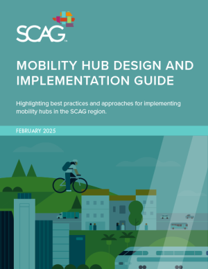
The SCAG “Mobility Hub Design and Implementation Guide” highlights best practices for implementing mobility hubs and mobility hub networks in the SCAG region. This guide discusses how to locate and prioritize candidate mobility hub sites, design and optimize sites, secure funding, explore partnership opportunities, and more.
The Connect SoCal 2024 Regional Transportation Plan/Sustainable Communities Strategy identified mobility hubs as a regional strategic investment to increase multimodal connectivity, manage the existing transportation system, and improve the traveler experience.
SCAG’s “Mobility Hub Design and Implementation Guide” provides a supportive framework for local implementation, equipping cities and local partners to conceptualize, design, and implement mobility hubs.
To learn more about the potential of mobility hubs to create new multimodal transportation options for communities all over Southern California, read the “Mobility Hub Design and Implementation Guide.”
Resources
Innovative Clean Transit Regional Assessment Study
In December 2018, the California Air Resource Board (CARB) adopted the Innovative Clean Transit (ICT) (Cal. Code Regs. Tit. 13 § 2023.1) regulation, which requires all public transit agencies to gradually transition to 100-percent zero-emission bus (ZEB) fleets by 2040. The regulation requires transit agencies to publish ZEB Rollout Plans and requires transit agencies to buy different ZEB sizes by year. SCAG affirmed its commitment to supporting efforts to advance a zero-emission transportation system through its adoption of Resolution No. 23-654-5 (April 2023), which established the Clean Transportation Technology Policy to support development, commercialization, and deployment of a zero-emission transportation system.
To support the region in meeting the transition deadline, SCAG kicked off the “Innovative Clean Transit Regional Assessment Study” in summer 2025. The study will support the region in efforts to transition to ZEBs by 2040 by assessing the region’s transit operators’ efforts to develop and implement ZEB Rollout Plans, evaluating readiness of the region to transition to zero-emission transit fleets, and the ongoing efforts aimed at transitioning to clean transit solutions throughout the region.
Study Objectives
The “ICT Regional Assessment Study” will:
- Assess ongoing efforts to transition to clean transit solutions throughout the region, including evaluations of existing fleets and supporting infrastructure.
- Identify any existing gaps within ZEB rollout plans and explore avenues for improvement and enhancement.
- Explore opportunities for enhanced coordination across agencies to streamline efforts and maximize effectiveness.
- Identify potential roles for SCAG in facilitating the transition to clean transit, including exploring opportunities for assistance through funding sources administered by SCAG.
Stakeholder Engagement
The project team will seek feedback from SCAG’s policy committees and the Regional Transit Technical Advisory Committee throughout the study. This engagement will begin with reviewing the goals and objectives of the study. In addition, the project team will assemble a list of transit agencies, bus manufacturers, charging infrastructure manufacturers, and utility providers, and reach out to them for information about the ZEB market, best practices, and existing conditions. Targeted outreach may be conducted through surveys and one-on-one meetings. Feedback gathered during this targeted outreach will help shape the implementation action plan and final report.
Project Timeline
The study kicked off summer 2025 and is expected to be completed by summer 2026. Key deliverables include a Zero-Emission Transit Vehicle Deployment Toolkit and implementation action plan, which can be incorporated into the “Innovative Clean Transit Regional Assessment Study.”
For more information, read the September 2025 staff report to the SCAG Energy and Environment Committee.
Contact
Priscilla Freduah-Agyemang
(213) 236-1973
contact@scag.ca.gov
Southern California Delivers The Goods

SCAG & Goods Movement
Goods movement is essential to support the economy and quality of life in the SCAG region. The regional goods movement system is a multimodal, coordinated network that includes deep-water marine ports, international border crossings, Class I rail lines, interstate highways, state routes and local connector roads, air cargo facilities, intermodal facilities, and distribution and warehousing clusters.
Whether carrying imported goods from the region’s international land border crossings or the San Pedro Bay Ports to regional distribution centers, supplying materials for local manufacturers, or delivering consumer goods to SCAG residents, the movement of freight provides the goods needed to sustain regional industries and consumers on a daily basis.
Southern California is a world leader in commerce and a major exchange point for international culture as businesses from across the globe trade via the region’s port, airport, and border crossing facilities. Goods movement is so woven into the fabric of life in Southern California that it is easy to take for granted that it will continue to deliver benefits without significant coordinated planning by local, regional, state, and national stakeholders. However, goods movement in Southern California faces serious challenges that will require considerable collaboration and investment to remain a cornerstone of the regional and national economy.
As the region’s metropolitan planning organization (MPO), SCAG seeks to optimize the goods movement network (FreightWorks) through increases in economic efficiency, congestion mitigation, safety and air quality improvements, and enhancements to system security.
- Related Links & Resources
Coalition for America’s Gateways and Trade Corridors (CAGTC)
CAGTC was established to bring national attention to the need to significantly expand U.S. freight transportation capabilities and to work toward solutions for this growing national challenge.FAST Act Freight Provisons
The FAST Act includes a number of provisions to improve the condition and performance of the national freight network and support investment in freight-related surface transportation projects.California Freight Advisory Committee (CFAC)
The CFAC meets quarterly to participate in the development of the California Freight Mobility Plan, serve as a forum for the discussion of freight-related topics, to help coordinate regional freight priorities with other organizations, and to advise the State on freight-related priorities, issues, projects, and funding needs.National Freight Advsory Committee (NFAC)
The National Freight Advisory Committee was created to help the U.S. Department of Transportation promote a safe, economically efficient, and environmentally sustainably freight transportation system
Southern California’s mobility network is supported by two main passenger rail operators Metrolink and Amtrak.
SCAG’s passenger rail program provides support and analysis for the region’s passenger rail planning efforts, including the Metrolink Southern California Optimized Rail Expansion (SCORE) program, the Los Angeles-San Diego-San Luis Obispo (LOSSAN) rail corridor, and Southern California sections of the California High-Speed Rail project. SCAG continues to promote the integration of passenger rail, transit-oriented development, and economic development strategies to support implementation of the Connect SoCal Regional Transportation Plan/Sustainable Communities Strategy and regional goals for mobility, sustainability, and economic growth.
Staff Contact
Priscilla Freduah-Agyemang
(213) 236-1973
agyemang@scag.ca.gov
- Related Resources & Links
- Integrated Passenger and Freight Rail Forecast Study
- Los Angeles-San Bernardino Inter-County Transit and Rail Study
Related Resources & Links
California High-Speed Rail Authority Reports
Integrated Passenger and Freight Rail Forecast Study

The SCAG region includes the Port of Los Angeles and the Port of Long Beach comprising the largest port complex in the Western Hemisphere driving substantial volumes of imports and exports. The region also includes the two largest Class I railroads in North America, BNSF Railway Co. and Union Pacific Railroad Corporation, which facilitate the movement of goods for local and national consumption. Both the rail and port systems are supported by extensive intermodal facilities, freight corridors and access roads, that connect with the largest industrial warehouse and distribution cluster in the United States. At the same time, the SCAG region provides an extensive commuter passenger rail system.
The SCAG Integrated Passenger and Freight Rail Forecast Study served as an initial approach for the region to assess freight and passenger rail in a comprehensive manner. The study evaluated existing and future rail volumes, identified infrastructure needs and prepared a strategic vision for implementation strategies in the region. The study was developed during the COVID- 19 pandemic and considered current assumptions about rail shipments and passenger service levels. The study provides recommendations on service expansion and capital improvements and serves as a resource to position the region for rail-related funding opportunities, aligning with core principles of SCAG’s Goods Movement Resolution.
Los Angeles-San Bernardino Inter-County Transit and Rail Study

SCAG, in cooperation with the San Bernardino County Transportation Authority (SBCTA) and the Los Angeles County Metropolitan Transportation Authority (Metro), conducted a transit and rail planning study for the corridor connecting the eastern San Gabriel Valley in Los Angeles County with the western San Bernardino Valley in San Bernardino County.
Several significant transportation improvements have been, or are currently being, planned in this corridor, including Metro A Line light rail transit, Metrolink San Bernardino Line commuter rail, hybrid rail, express bus, bus rapid transit, and Interstate 10 high-occupancy vehicle lanes and ExpressLanes. The study sought to develop a coordinated transit and rail strategy that best serves the transportation needs of the residents, workers, and businesses that rely on this corridor.
Study Objectives
- Understand the market for transit and rail travel in the corridor, including travel to and from Ontario International Airport (ONT).
- Estimate the potential benefits and costs associated with different transit and rail improvement options for the corridor.
- Recommend a path forward for cost-effective transit and rail improvements, focusing on coordinating plans for the Metro A Line, Metrolink, and access to ONT.
Downloads
- Los Angeles and San Bernardino Inter-County Transit and Rail Connection Study Final Report
- News Release: October 11, 2018, San Bernardino-LA County Transit Corridor Requires Multiple Solutions Working Together, Legislators and Transportation Experts Told
- Project Fact Sheet: (English) | (Spanish)
- Frequently Asked Questions: (English) | (Spanish)
Study Area
The study corridor area includes portions of the cities of Claremont, La Verne, Montclair, Ontario, Pomona, Rancho Cucamonga, and Upland and focuses on the Metro A Line Foothill Extension, the Metrolink San Bernardino Line, and the San Bernardino (I-10) freeway.
SCAG’s Corridor Planning program supports planning new corridors to service the future mobility needs of the region and to identify improvements to existing corridors to maintain them as vital elements of the transportation system for years to come.
The state of California, SCAG, and local governments are committed to transportation safety for all people in our region. Each year, metropolitan planning organizations, such as SCAG, work with the state to assess fatalities and serious injuries on all public roads and develop annual safety targets to comply with federal requirements.
- SoCal Transportation Safety Resource Hub
- Transportation Safety Regional Existing Conditions
- SCAG Region Safety Targets
- Regional High Injury Network
- Transportation Safety Tools
SoCal Transportation Safety Resource Hub
To support local jurisdictions in their efforts to advance transportation safety and help the region achieve its annual safety targets, SCAG developed the SoCal Transportation Safety Resource Hub, a centralized source of SCAG’s transportation safety programs, data, and resources, featuring:
- A summary of regional transportation safety goals and targets.
- An overview of SCAG’s transportation safety existing conditions.
- An interactive map of SCAG’s Regional High Injury Network along with downloadable data and resources to support local jurisdictions in creating their own high injury network (HIN).
- Opportunities to get involved through SCAG’s current safety efforts.
- Data, tools, funding, and other resources from SCAG and other organizations.
Transportation Safety Regional Existing Conditions
On average, traffic collisions in Southern California kill 1,616 people, seriously injure 6,517, and injure a total of 119,000 people each year according to statistics from the ”2025 Transportation Safety Regional Existing Conditions Report.” The report reviews the region’s roadway collision data, patterns, and trends to inform the development of regional safety targets and be a reference in planning improvements and actions.
A high-level summary of the report is available on the Existing Conditions page of the SoCal Transportation Safety Resource Hub in addition to resources for local jurisdictions for sharing local data in their own communities. Fact sheets featuring key safety statistics from the “2025 Transportation Safety Regional Existing Conditions Report” are available for each of the six SCAG counties:
Additional analysis and strategies regarding transportation safety are available in the Connect SoCal 2024 “Mobility” technical report.
Download Past Reports
SCAG Regional Safety Targets
SCAG establishes annual regional traffic safety targets for the five performance measures presented in the accompanying table and updates these targets to evaluate progress toward safer roadways in the SCAG region. While the annually updated targets are based on observed regional safety data, trends analysis, and modeled performance assumptions, SCAG continues to endorse a “Vision Zero” transportation system safety goal, which acknowledges that even one traffic-related fatality is unacceptable.
Achieving “Vision Zero” requires implementation of a safe system approach, which is based on the principle that humans make mistakes and have limited ability to tolerate crash impacts. The safe system approach is implemented through roadway design features and traffic management strategies that minimize opportunities for human error and lessen the impact of collisions, reducing the risk of traffic-related fatalities and serious injuries.
The SCAG regional safety targets for 2026 are as follows:
| Performance Measure | SCAG 2026 Target* |
|---|---|
| Number of Fatalities: | 1,811.6 |
| Rate of Fatalities per 100 million Vehicle Miles Traveled (VMT): | 1.11 |
| Number of Serious Injuries: | 7,302.8 |
| Rate of Serious Injuries per 100 million VMT: | 4.48 |
| Total Number of Non–motorized Fatalities and Serious Injuries: | 2,478.2 |
2026 SCAG Regional Safety Targets adopted Feb. 5, 2026 *Targets are based on a five-year rolling average.
Regional High Injury Network
High injury networks (HINs) are one of many strategies local agencies can use to begin addressing traffic fatalities and serious injuries. HINs identify stretches of roadways where the highest concentrations of collisions resulting in fatal or serious injuries occur on the transportation network.
SCAG’s Regional High Injury Network is a network of designated corridor-level segments where the highest concentrations of serious and fatal collisions occur over the most recent five years of available collision data at the time of publishing (2015-2019). SCAG’s Regional High Injury Network shows that 65 percent of all fatal and serious injuries occurred on just 5.5 percent of the regional transportation network. For more information about the development of SCAG’s Regional High Injury Network, view the "Regional High Injury Network Methodology and Analysis" report.
Local jurisdictions in California may be even more interested in developing their own high injury network due to the adoption of Assembly Bill 43, which will permit agencies with designated safety corridors (e.g., high injury networks) to lower speeds on those roads. The High Injury Network page of the SoCal Transportation Safety Resource Hub features several resources:
- A description of HINs and why they matter.
- Recommendations and a checklist for developing HINs.
- Webinars on the technical components of collision data and HINs.
- Examples of locally adopted HINs.
To learn more about where collisions occur throughout Southern California, visit the High Injury Network page of the SoCal Transportation Safety Resource Hub.
Transportation Safety Tools
Explore SCAG's transportation safety tools designed to support data-informed decisions that improve traffic safety and save lives. These platforms support planning and investments for safer streets across Southern California.
SoCal Community Transportation Safety Modeling Tool
The SoCal Community Transportation Safety Modeling Tool enables jurisdictions to visualize and predict potential safety performance impacts of proposed land use development scenarios, then plan accordingly to equitably reduce the risk of future collisions at the community level.
Explore how this tool can support safer and equitable community planning online.
SoCal Transportation Safety Predictive Modeling and Analysis Platform
The SoCal Transportation Safety Predictive Modeling and Analysis Platform, funded by the California Office of Traffic Safety, enables local and regional agencies to analyze, model, and predict traffic safety performance and risk at the roadway segment level using historic crash data and advanced predictive analytics.
The platform supports a proactive, data-driven approach to reducing the number and severity of traffic collisions, including fatalities and serious injuries. Explore how this platform can support your jurisdiction’s vision zero initiatives, safe system strategies, and data-driven investment decisions.
To request access to the platform, please email contact@scag.ca.gov.
The Southern California Association of Governments’ (SCAG) Transportation Finance Program seeks to optimize the region’s transportation systems by planning for the long-term financial needs of the region. SCAG is working to address funding shortfalls by researching and promoting innovative financing techniques, and developing strategies for the Regional Transportation Plan (RTP), so that the greatest amount of transportation dollars are available to the region. In doing so, all forms of potential funding for transportation are analyzed and evaluated by SCAG.
2012-2035 RTP/SCS Financial Plan Highlights

You can access the financial plan chapter of the 2012-2035 RTP/SCS either via the iRTP version or as part of the 2012-2035 RTP/SCS print version in Adobe Acrobat PDF format. The Transportation Finance Appendix is also available as an Adobe Acrobat PDF file.
Status of the HTF
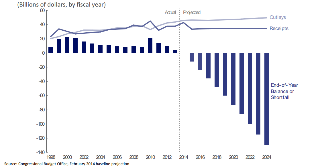
The CBO estimates that the highway account of the trust fund may have difficulty meeting all obligations during the latter half of fiscal year 2014. Additional details are available at: Testimony on the Status of the Highway Trust Fund
Highway Trust Fund Ticker

Based on current spending and revenue trends, the U.S. Department of Transportation estimates that the Highway Account of the Highway Trust Fund will encounter a shortfall before the end of fiscal year (FY) 2014. See USDOT HTF Ticker for more details.
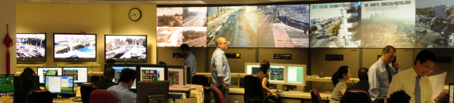
In Southern California, there are several Intelligent Transportation Systems (ITS) architectures that may be applicable to an ITS project. SCAG has developed a Southern California Regional ITS Architecture that addresses multi-county issues: those projects, programs, and services that require connectivity across county boundaries or are deployed at a multi-county level. Secondly, each County has developed a Regional ITS Architecture to provide a framework for local deployment of ITS applications. A third “layer” is also in place at the state level: the California ITS Architecture and System Plan addresses those services that are rolled out or managed at a state level or are interregional in nature.
SCAG’s Southern California Regional ITS Architecture provides a framework for ITS planning that promotes interoperability and communication across jurisdictional boundaries. Projects developed under a regional framework extend the usefulness of any single project by making information easily accessible for operators and users of the system. The Southern California Regional ITS Architecture is intended to provide a resource for project sponsors and transportation providers that coordinates cross-county planning efforts in the SCAG region and facilitates project development (planning, design, implementation, etc.).
Regional ITS projects, or transportation projects (both highway and transit) with ITS elements, that want to be eligible for Federal transportation funding are required to be consistent with the Southern California Regional ITS Architecture pursuant to 23 CFR 940.9 and 940.11. In addition, such projects must comply with system engineering requirements and applicable Federal standards that have been adopted for the implementation of ITS.

SCAG is conducting the “2024-2026 SoCal Transportation Study” to better understand the transportation needs of Southern California residents. Thousands of residents in the region will receive invitations to participate in this voluntary transportation study.
Participation in the study is essential to generate insights about how the region can maintain and enhance mobility, accessibility, and connectivity for its growing population amidst emerging travel choices and evolving travel patterns. The information collected will be instrumental in planning and prioritizing future transportation improvements.
Resource Systems Group, Inc. (RSG), an independent research firm, is administering this study on behalf of SCAG. Residents are invited to participate using an app called rMove™ on their smartphones, online, or by phone.
The study involves questions about general household information as well as travel details for a one-week period. Information collected in this study will be treated as confidential. We are committed to protecting the confidentiality, integrity, and security of your personal information. Contact information will be kept separate from the responses and destroyed once the study concludes. For more information, please refer to the full privacy policy.
Participate
Thank you for your interest in the SoCal Transportation Study. The study is currently closed for new participants.
Smartphone App
Download the smartphone app rMove and log in with your access code to participate in the study. Just go about your life. rMove will log your travel and ask questions about your trips for one week.
Participants may download the rMove app from the Android Google Play or Apple App Store.
Online
Take the study online and log in with your access code to participate.
Phone
Call toll-free to complete the study in English, Español (Spanish), 繁體中文 (Traditional Chinese), Tiếng Việt (Vietnamese) and 한국어 (Korean).
1-833-313-9555.
The call center is managed by WestGroup.
Frequently Asked Questions
- What is This Study All About?
We want to learn how, when, where, and why people travel in and outside the region. We invite you to log your travel to help us understand regional transportation patterns. By participating, you help us plan for future transportation improvements that benefit our community.
- Why Should I Participate?
Your participation is essential to representing households like yours in regional transportation plans.
- How Was I Selected to Participate?
Households were selected by mailing address randomly from Southern California to ensure a comprehensive representation of the community.
- Who is sponsoring this study?
This study is sponsored by the Southern California Association of Governments (SCAG), with additional support from the Los Angeles County Metropolitan Transportation Authority (LA Metro).
- What information of mine is being collected?
RSG will collect and use certain personal information from your study: travel information, demographics, household composition, contact information, and computer settings. We will not disclose or share personal information we collect from you except as required by law or described in the project-specific documentation and our privacy policy.
- Who should sign up?
Please have only one household member complete the initial registration for the study. If your household opts to use the app, please have all household members download the app and use the participation code provided in our email. For the one-day study, please answer your entire household either online or by phone.
- How much time does it take to participate?
Registering for the study takes about 10 minutes. After registering, you’ll receive instructions on how to log your trips and complete the questionnaire. For households using the rMove smartphone app, logging trips takes about five to ten minutes per day over seven days. For households reporting trips online or by phone, it takes about ten minutes per household member for one day of reporting
- What do I get for participating?
Once all members of your household have reported their trips and completed their questionnaires, you will receive a gift card. Once your household is registered, all household members need to participate in the study to be eligible for gift cards. If your household participates using the rMove smartphone app, each participating adult will receive a gift card (e.g., a household with two adults receives two gift cards). Households that report their trips online or by phone will receive a single gift card per household.
- Who can participate? Can my neighbor or friend participate?
Participation is limited to selected households that received a mailed invitation to ensure the validity of the data collected.
- What is a trip?
A trip is defined as any time you travel more than 100 feet and conduct an activity at a different address, including activities such as arriving at school or work, getting coffee on the way to work, walking to the bus stop, stopping for gas or recharging vehicle, walking your dog, or using a drive-through.
- What if I don’t travel much?
Any amount of travel, even if you don’t make any trips, is valuable. Remember that short trips, such as walking the dog, count too.
- What if my transportation habits during the study aren’t my “typical” habits?
No problem! We encourage your participation regardless of whether your transportation habits during the study align with your routine.
- I was invited to use the study smartphone app rMove. How does it work?
After you download rMove and sign up for the study, the app will log your trips for one week while you go about your daily life. Each day, you’ll be asked to complete a short daily questionnaire about your transportation habits as well as a trip diary about each trip you make.
- How do I participate with rMove?
Before your assigned trip reporting start date, you’ll receive an email with instructions to download and activate the rMove app. Once installed and running properly, rMove will log your trips. Shortly after you complete a trip, rMove will generate a trip diary record, prompting you to provide details such as how and why you made the trip. You’ll also receive a few questions in the app each morning about the previous day’s trips. You can answer these questions at your convenience throughout the day, but please refrain from responding while driving for safety reasons!
- Why is the study using smartphones to collect my information?
The rMove app allows for more detailed trip information collection than a traditional travel diary. For example, the app collects each trip path, which helps understand congestion and route choices. Additionally, respondents may find it easier to use rMove than remembering trip details. Rest assured all data collected on your smartphone is strictly confidential along with the information collected in the study. This study’s privacy policy is available online.
- How are my results used?
Your responses, combined with those of other participants throughout Southern California, contribute to a comprehensive understanding of travel behaviors in your community and throughout Southern California. This collective insight assists transportation planners in assessing how changes to transportation infrastructure and policy impact factors such as commute time and accessibility to essential activities.
- How is my personal privacy protected?
We are committed to protecting the confidentiality, integrity, and security of your personal information. Our Privacy Policy is intended to help you understand how we collect and safeguard your information. For more information, view the study’s full privacy documentation.
- What if I never received my access code?
Please check your email junk or spam folder in case the email was routed there. If you don’t find it, please contact us for further assistance.
- Why do you need to know my demographics, like race and income?
Understanding the diverse demographics of Southern California residents ensures that our study captures a true representation of the region’s population. Travel patterns often correlate with demographic factors and geographic locations where residents live or work. Demographic information provides valuable insights for future transportation planning and improvements.
- Why do you need to know about my children’s travel?
Children’s trips to and from school account for a significant portion of overall travel activity for household routines, including the travel patterns of their parents or caregivers, through school-related trips and the planning of other errands, such as grocery shopping. By understanding the timing and methods of children’s school commutes, transportation planners can better assess household travel behaviors and improve transportation planning to ensure the safety and efficiency of school-related trips.
- Why isn’t the app recording my trips?
If you encounter issues with rMove app trip recording, please try restarting your smartphone. Restarting typically resets your location settings and resolves tracking issues with the app.
- Can I remove a household member if they no longer want to participate?
Unfortunately, once the initial sign-up questionnaire is complete, we cannot remove participating household members. Because this is a household-level transportation study, accurate trip data requires participation from all related adult household members.
- If I drive for my job (delivery, bus, rideshare driver, etc.), do I have to track all my trips?
While the rMove app generates a trip diary record for every trip made, we understand that continuous tracking during work hours can be impractical. You can turn off the app tracking during these busy work hours and turn it back on during your normal personal trips. To disable location settings, Go to Settings, find rMove within apps, and disable location.
- What if I or someone in my household will be out of town/state during some of my travel period?
If your household participates using the rMove smartphone app and you or someone in your household will be in town for at least one of your assigned trip reporting dates, we encourage you to participate in the week-long study. If you or someone in your household will be out of town or out of the state for the entire trip reporting period, please contact us to arrange for a new trip reporting period.
- Why don’t I have any studies to answer even though I’m making trips?
Your trip diary records should populate when you open the rMove app. If you do not see any trip diary records to answer despite making trips, please restart your smartphone. If the issue persists after restarting your smartphone, please contact us for assistance.
- When do I get my gift card?
Please allow two to three weeks for gift card processing after you have completed the study.
- What do I do if I haven’t received my gift card after two to three weeks?
If you chose a digital gift card and haven’t received it, please check your email junk or spam folder. Please contact us for assistance if you are unable to locate your digital gift card. If you chose a physical mailed card, please contact us for assistance with your mailing address. We will ensure it is sent to you promptly.
- Contacts
Submit A Support Request
Need assistance? E-mail us at help@SoCalTransportationStudy.com.
Please include your participation access code if you know it.
Call Toll-Free
- 833-313-9555
- Hours:
- Monday through Thursday: 8 a.m. – 5 p.m. PST
- Friday: 8 a.m. – 4 p.m. PST
- You may also leave a message with the best time and number for us to return your call.
The Planning for Main Streets project is a regional effort led by SCAG to reimagine state highway corridors that double as community main streets. The project focuses on four corridors—State Route (SR) 1, SR 18, SR 39, and SR 86 in Los Angeles, San Bernardino, Orange, and Imperial counties—and aims to transform these roads into people-centered places that balance transportation needs with community well-being. Through this initiative, SCAG and its partners will address transportation inequities, improve safety and mobility for all users, and align infrastructure with everyday needs of residents, workers, and visitors.
This project includes planning, design, and community engagement to create safer, more accessible, and vibrant streetscapes. By collaborating with local jurisdictions, community organizations, and the public, the project will identify feasible improvements and implementation strategies that promote equity, health, and sustainability in the region.
Project Goals
The goals of the project are to:
Improve safety and accessibility for all modes of transportation.
Enhance quality of life in equity-priority communities.
Align state highway design with local community needs.
Foster local support and ownership of project outcomes.
Develop grant-ready design concepts to support future funding opportunities.
Contact
For more information on the study, please contact us here.
Study Work
Over the two-year study period (2025-2027), SCAG and its partners will be working on:
Understanding the Corridors
The project begins with a comprehensive review of existing conditions on each corridor, assessing traffic patterns, sidewalk and bike facility availability, transit access, crash data, and environmental conditions. The team will also review relevant planning documents to ensure alignment with local and state goals.
Community Engagement
Engagement will include walk audits, surveys, workshops, and pop-up events using tools like the Go Human Kit of Parts. Community advisory committees and technical advisory committees will guide each phase, ensuring that the designs reflect local values and priorities.
Design and Evaluation
Draft design concepts will be developed for each corridor, taking into account community input and technical feasibility. Designs will propose new street configurations that better serve pedestrians, bicyclists, and transit riders while accommodating vehicle travel. The concepts will be refined through workshops and evaluated using clear criteria related to safety, mobility, equity, and sustainability.
Final Recommendations and Reporting
The final stage will involve preparing grant-ready materials, fact sheets, and a comprehensive report for each corridor. These will include detailed conceptual designs, cost estimates, and potential funding sources. The final concepts will be presented to local governing bodies and SCAG committees for feedback and approval, setting the stage for future implementation.
Study Corridors
- State Route 1 From Lomita to Long Beach
State Route 1 From Lomita to Long Beach
Image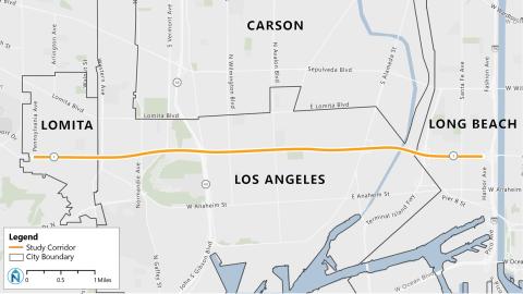
Study Area: State Route 1 from Pennsylvania in the city of Lomita to Harbor Avenue/I-70 ramps in city of Long Beach, approximately 6.5 miles.
State Route (SR) 1 is one of the busiest corridors in Los Angeles County due to its proximity to I-70, SR 103, I-110, and the ports of Los Angeles and Long Beach, which all generate high vehicular and freight traffic in the area. Multiple transit services, such as the Los Angeles County Metropolitan Transportation Authority, Long Beach Transit, Los Angeles Department of Transportation, and Torrance Transit, operate along the study corridor. SR 1 also links the downtown areas of Lomita, Harbor City, and Wilmington and runs through the industrial zones of Wilmington and Long Beach as well as a variety of residential areas and businesses.
City Partners
Image Image
Image Image
Image
Transportation Agency Partners
Image Image
Image Image
Image Image
Image Image
Image Image
Image
- State Route 18 in San Bernardino
State Route 18 in San Bernardino
Image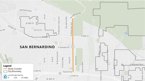
Study Area: State Route 18 from Arrowhead Road to 30th Street in San Bernardino, approximately two miles.
State Route (SR) 18 is a gateway to two major recreation destinations, Lake Arrowhead and San Bernardino National Forest, which draw many visitors. The corridor is used every day by local community members traveling to and from their homes, schools at Parkdale Drive, businesses along 40th Street, and SR 210.
City Partners
Image
Transportation Agency Partners
Image Image
Image
- State Route 39 from Stanton to Westminster
State Route 39 from Stanton to Westminster
Image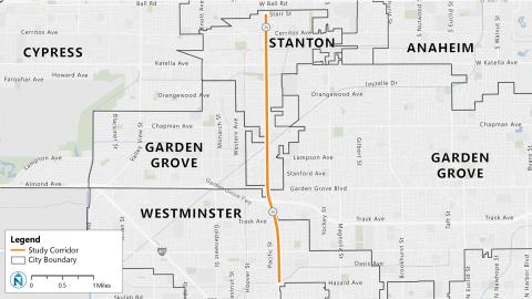
Study Area: State Route 39 from Starr Street in Stanton to Hazard Avenue in Westminster, approximately 4.5 miles.
State Route (SR) 39 is a major corridor in Orange County with high traffic volumes due to its multiple strip malls, office parks, and intersection with SR 22. The corridor is also served by several Orange County Transportation Authority bus routes.
City Partners
Image Image
Image
Transportation Agency Partners
Image Image
Image
- State Route 86 (Main St/1st St/Brawley Ave) in Brawley
State Route 86 (Main St/1st St/Brawley Ave) in Brawley
Image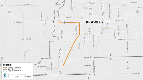
Study Area: State Route 86 from Las Flores Drive to Legion Road in Brawley, approximately two miles.
SR 86 is a gateway to Brawley’s Main Street, the city’s downtown core, lined with many businesses. Residents use this road to travel between their homes and surrounding communities. The Brawley Circulator and Imperial Valley Transit operate in areas adjacent to the corridor.
City Partners
Image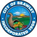
Transportation Agency Partners
Image Image
Image Image
Image
Get Involved
Community engagement began fall 2025. There are several opportunities to provide input:
Workshops
In April and May, SCAG will host online workshops to introduce the local projects, review existing conditions, and gather community input. Your feedback will help inform corridor priorities and potential recommendations to improve safety, mobility, and placemaking.
Register online using the following links to attend one or more workshops.
Workshop Dates
Each workshop will be held from 6-7 p.m.
- San Bernardino (SR-18): Monday, April 13
- Lomita (SR-1): Thursday, April 16
- Los Angeles (SR-1): Monday, April 20
- Long Beach (SR-1): Monday, April 27
- Westminster (SR-39): Thursday, April 30
- Stanton (SR-39): Monday, May 4
- Brawley (SR-86): Monday, May 11
Surveys
Thank you for participating in the study corridor surveys, which were open from December 2025 to February 2026. The project team is analyzing results and will share updates soon.
- SR 1 (Los Angeles County)
- Community Walk Audit
- Long Beach
- Date: Dec. 4, 2025
- Time: 9 a.m.
- Location: Winchell's Donut House (1695 W. Pacific Coast Hwy., Long Beach, CA 90810)
- Walk Audit Summary
- Los Angeles
- Date: Dec. 4, 2025
- Time: 3 p.m.
- Location: Banning Recreation Center
- Walk Audit Summary
- Lomita
- Date: Dec. 3, 2025
- Time: 8:10 a.m.
- Location: Miss Donut & Bakery (1871 Pacific Coast Hwy., Lomita, CA 90717)
- Walk Audit Summary
- Long Beach
- Community Walk Audit
- SR 18 (San Bernardino County)
- Community Walk Audit
- Date: Nov. 18, 2025
- Time: 3:30 p.m.
- Location: Wildwood Park (parking lot off N. Waterman Ave. & E. 40th St., Brawley, CA 92404)
- Walk Audit Summary
- Community Walk Audit
- SR 39 (Orange County)
- Community Walk Audit
- Stanton
- Date: Dec. 2, 2025
- Time: 10 a.m.
- Location: City of Stanton Corporate Yard (8100 Pacific St., Stanton, CA 90680)
- Walk Audit Summary
- Westminster
- Date: Dec. 5, 2025
- Time: 9 a.m.
- Location: Bob's Burgers (13891 Beach Blvd., Westminster, CA 92683)
- Walk Audit Summary
- Stanton
- Community Walk Audit
- SR 86 (Imperial County)
- Community Walk Audit
- Date: Dec. 11, 2025
- Time: 8:30 a.m.
- Location: Witter Elementary School (corner of S. 1st St. and K St., Brawley, CA 92227)
- Walk Audit Summary
- Community Walk Audit
Project Timeline
Resources
Check out the study’s resources when completed.
Active transportation refers to human powered transportation, and low speed electronic assist devices. Examples include but are not limited to bicycles, e-bicycles, tricycles, wheelchairs, electric wheelchairs, scooters, e-scooters, skates and skateboards.
Active transportation is a critical component in meeting environmental, economic and equity goals, as well as supporting jurisdictions in addressing their diverse transportation needs.
Contact
For more information on the Active Transportation Program, please contact:

The Regional Pilot Initiatives (RPI) program is focused on demonstrating innovative, next-generation technologies and models of regional significance, specifically those at the intersection of innovation and transportation equity, to guide the region toward a more sustainable and prosperous future.

SCAG’s Aviation Program is responsible for developing the aviation element of the Connect SoCal Regional Transportation Plan/Sustainable Communities Strategy, gathering data and conducting research on aviation trends and issues, collaborating with airports and partner agencies (e.g., the Federal Aviation Administration and the Caltrans Division of Aeronautics) on airport ground access and aviation systems planning, staffing the Aviation Technical Advisory Committee, and providing information and data to the Transportation Committee.

Southern California is in the midst of a mobility paradigm shift. With growing availability of data systems, platforms, and service providers, municipalities are rethinking how to leverage innovation to provide new mobility options and improve existing services. In 2018, SCAG and the Mobile Source Air Pollution Reduction Committee (MSRC) created the Future Communities Pilot Program (FCPP), a new $2.7 million grant program that would allow local cities and counties to implement new technology and data solutions, while reducing vehicle miles traveled (VMT) and implementing SCAG’s 2016 Regional Transportation Plan/Sustainable Communities Strategy. Examples of VMT reducing projects considered include fleet telematics, Internet of Things applications, route optimization, and Mobility as a Service pilots.
Southern California Delivers The Goods
SCAG & Goods Movement
Goods movement is essential to support the economy and quality of life in the SCAG region. The regional goods movement system is a multimodal, coordinated network that includes deep-water marine ports, international border crossings, Class I rail lines, interstate highways, state routes and local connector roads, air cargo facilities, intermodal facilities, and distribution and warehousing clusters.
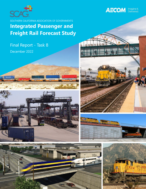
Integrated Passenger and Freight Rail Forecast Study
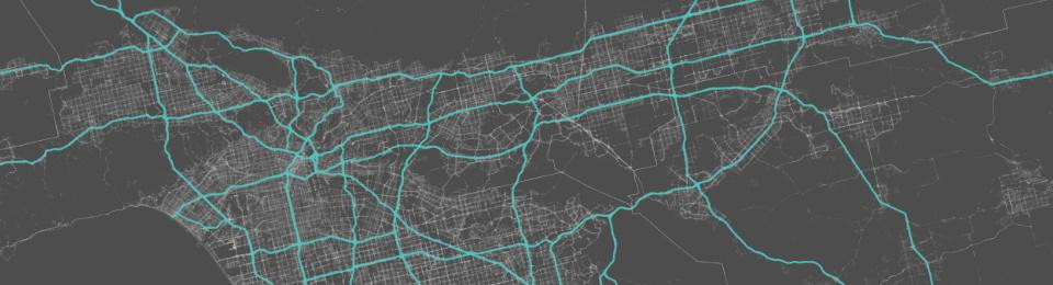
SCAG’s Corridor Planning program supports planning new corridors to service the future mobility needs of the region and to identify improvements to existing corridors to maintain them as vital elements of the transportation system for years to come.
The state of California, SCAG, and local governments are committed to transportation safety for all people in our region. Each year, metropolitan planning organizations, such as SCAG, work with the state to assess fatalities and serious injuries on all public roads and develop annual safety targets to comply with federal requirements.

The Southern California Association of Governments’ (SCAG) Transportation Finance Program seeks to optimize the region’s transportation systems by planning for the long-term financial needs of the region. SCAG is working to address funding shortfalls by researching and promoting innovative financing techniques, and developing strategies for the Regional Transportation Plan (RTP), so that the greatest amount of transportation dollars are available to the region. In doing so, all forms of potential funding for transportation are analyzed and evaluated by SCAG.
In Southern California, there are several Intelligent Transportation Systems (ITS) architectures that may be applicable to an ITS project. SCAG has developed a Southern California Regional ITS Architecture that addresses multi-county issues: those projects, programs, and services that require connectivity across county boundaries or are deployed at a multi-county level. Secondly, each County has developed a Regional ITS Architecture to provide a framework for local deployment of ITS applications. A third “layer” is also in place at the state level: the California ITS Architecture and System Plan addresses those services that are rolled out or managed at a state level or are interregional in nature.
SCAG’s Southern California Regional ITS Architecture provides a framework for ITS planning that promotes interoperability and communication across jurisdictional boundaries. Projects developed under a regional framework extend the usefulness of any single project by making information easily accessible for operators and users of the system. The Southern California Regional ITS Architecture is intended to provide a resource for project sponsors and transportation providers that coordinates cross-county planning efforts in the SCAG region and facilitates project development (planning, design, implementation, etc.).
Regional ITS projects, or transportation projects (both highway and transit) with ITS elements, that want to be eligible for Federal transportation funding are required to be consistent with the Southern California Regional ITS Architecture pursuant to 23 CFR 940.9 and 940.11. In addition, such projects must comply with system engineering requirements and applicable Federal standards that have been adopted for the implementation of ITS.

SCAG is conducting the “2024-2025 SoCal Transportation Study” to better understand the transportation needs of Southern California residents. Thousands of residents in the region will receive invitations to participate in this voluntary transportation study.


