

Request for Proposals
SCAG relies heavily on outside consultants and other vendors to help accomplish our overall mission and objectives of the agency.
Event and Meeting Calendar
Check the SCAG calendar for an updated and full list of upcoming events, meetings and activities.
Regional Data Platform
A revolutionary GIS system for seamless interagency collaboration, data sharing and support for local and regional planning across jurisdictions.
Agendas and Minutes
View current and past agendas and minutes.
FEATURED WORK
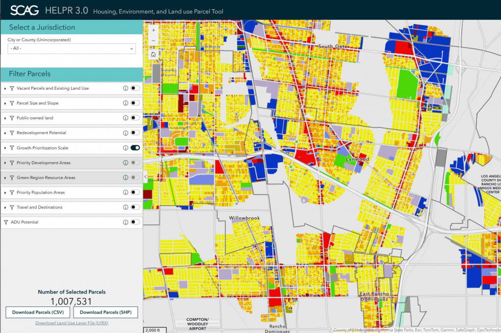
Housing, Environment, and Land Use Parcel Tool (HELPR) 3.0
HELPR 3.0 is a web-mapping tool developed by SCAG to help local jurisdictions and stakeholders understand local land use, site opportunities, and environmental sensitivities in the context of regional objectives.
Local Investments Dashboard
This dashboard shows SCAG-funded efforts by jurisdiction to support implementation of shared regional planning goals and meet community needs.

Southern California Clean Cities Coalition Strategic Plan
The Plan details the various actions and strategies that SCAG and the Southern California Clean Cities Coalition can undertake to support the advancement of affordable, efficient, and clean transportation technologies.

Executive Director’s Monthly Report, June 2025
The June 2025 Executive Director’s Report covers the agency’s major activities, key programs, and accomplishments over the past month.

SCAG Economic Roundtable Update 2025
SCAG’s Economic Roundtable met on May 22 for its second quarterly meeting in 2025 to review trends, data and current events impacting the region’s economy.