Ready for 2020
Who Are We Planning For?
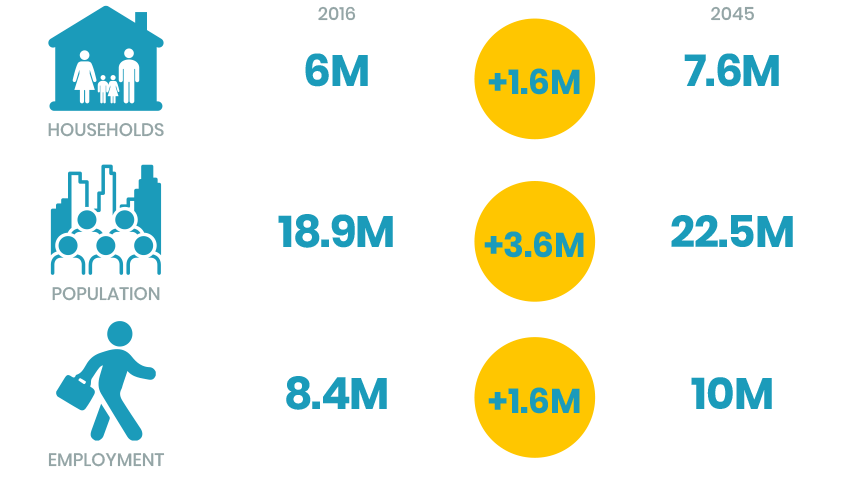
Connect SoCal – The 2020-2045 Regional Transportation Plan/Sustainable Communities Strategy is a long-range visioning plan that balances future mobility and housing needs with economic, environmental and public health goals. As we think about what the future looks like, we must also consider what types of demographic and economic changes will occur over the lifespan of the plan. With the region’s population set to increase by 3.6 million over the next 25 years, what works for Southern California in 2020 might not necessarily work in 2045.
Although several factors will inform the planning decisions made for our region’s future, one thing is abundantly clear: our population is changing—a declining birth rate, an aging population, and domestic outmigration. As a result, the needs of our region will change over the coming decades.
Where Will We Grow?
The SCAG region consists of 191 cities and six counties in an area covering more than 38,000 square miles. Taking into consideration the 19.2 million people that already call Southern California home, as well as the expected increase of 3.6 million residents in the region by 2045, we must carefully consider how our region can accommodate growth while balancing resource conservation, housing demands, and economic expansion concurrently with a rapidly changing climate. These regional challenges necessitate thinking beyond jurisdictional boundaries.
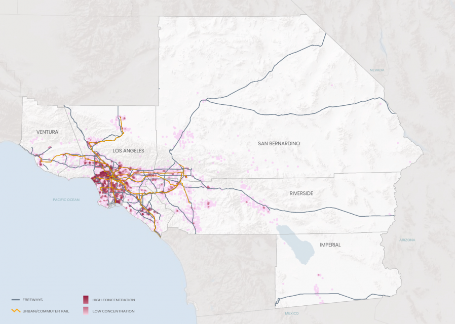
At the same time, California is in the midst of a long-term structural housing shortage and affordability crisis. The housing crisis is a two-part problem – a shortage of housing and a lack of affordability. The region’s housing supply has not kept up with population growth. From 2006 to 2016, an additional 930,000 people called Southern California home. But over a comparable period, only one new housing unit was created for every 3.32 persons added. Many areas in Riverside and San Bernardino Counties were appealing for development due to the availability of lower priced land, which attracted new residents looking for larger or lower priced housing. Jobs, however, did not follow in proportion to housing unit growth in these communities. As a result, residents of the Inland Empire have to travel longer distances on average than other Southern Californians to reach their jobs, increasing congestion, automobile dependency, greater wear and tear on our roads, increasing traffic collisions, air pollution, and limiting the effectiveness of public transit.
How Will We Connect?
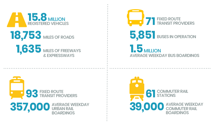
Southern California covers a large geographic area, and therefore many think of our region as a seemingly endless network of freeways and highways where the “car is king.” The six-county SCAG region, however, is more than that – our region is home to a multi-modal system that connects the people and goods of one of the world’s largest mega-regions to the destinations where they live, work and play. With over 1,600 miles of freeways and expressways, over 100 miles of urban rail lines, over 4,000 miles of bikeways, and six major airports, Southern California needs multiple modes of transportation to move both people and goods. As we look toward the future, we will need to think about how our region will connect internally, to the rest of the nation, and to the world.
Our current transportation system is also the highest source of greenhouse gas emissions. According to Next 10’s Green Innovation Index, vehicle emissions hit a record high in 2017, accounting for 41 percent of the state’s total. With ambitious state mandates to reduce our emissions within the next fifteen years, we need to examine what kinds of alternatives to driving can be utilized to provide a cleaner travel experience, whether it be for work or leisure.